And so it begins...the stakes have just been raised by the NWS.
Read Special Weather Statement here
Vote in the 'Snow Poll' to the left...voting will close SOON!

Reporting weather from an experienced perspective.
Monday, December 31, 2007
Here Comes The Cold (and Snow?)
The deep freeze train is on it's way to Middle TN. After a warm day for us where we'll see highs in the mid 50's...a strong cold front will bring much colder temperatures to our region. Overnight tonight, we should see some showers switch over to light snow...by tomorrow (January 1st)..temperatures will fall all day with a chance for snow...then tomorrow night, we should see lows from 12 to 15 degrees...that's COLD.
Our Local Forecast Here
The computer models aren't real exciting for accumulating snow for us...
NWS Forecast Discussion
Don't forget to cast your vote in our snow poll...it'll close today!
Our Local Forecast Here
The computer models aren't real exciting for accumulating snow for us...
NWS Forecast Discussion
Don't forget to cast your vote in our snow poll...it'll close today!
Sunday, December 30, 2007
New Year's Eve!!
Well, here we are at the CLOSE of 2007, it has been a fantastic year at my home. Here is a brief sample of our 1st quarter....
January:
Fired up this blog for a few test runs in the later part of the month...who would've known that over 11,000 of you would stop by to read and chat with me......
February:
Found out my wife and I would be having a baby in October!.....
March:
Celebrated my 44th birthday....yeah, I know I'll be 62 when she graduated high school :)
More to come!
Keep on voting in the SNOW POLL..the poll will close on Monday at 5 pm!!
The CWG Official Snow Poll
Just posted this poll to the right about whether or not it'll snow on January 1st or 2nd. The forecasting models were in agreement for something, but backed off some! Typical Tennessee winter! You could read the latest NWS Forecast Discussion here. Oh, go and vote! :)
Snow Vanishing?
According to our latest forecast from the NWS, it appears they are backing off from the snow forecast....interesting! I'll post more later on this subject. You can access our local forecast to the right of this post.
Saturday, December 29, 2007
New Year's Snow?

I've been patroling the different sites watching how the professionals are viewing the latest information from the computer forecasting models. Here are some discussion threads from the National Weather Service in Louisville, KY and Nashville, TN.
First from Louisville..
MONDAY NIGHT THROUGH WEDNESDAY...A STRONG COLD FRONT WILL SWEEP ACROSS THE REGION MONDAY NIGHT (NEW YEARS EVE). THE ISSUE HERE IS AVAILABLE MOISTURE. THE GULF DOES NOT HAVE TIME TO OPEN UP SO MOISTURE WILL BE FROM THIS DYNAMIC SYSTEM.THE OPERATIONAL GFS IS THE MOST AGGRESSIVE IN PRODUCING QPF FROM 00Z TO 12Z TUESDAY. THE LATEST GFS ENSEMBLE, THE CANADIAN ENSEMBLE, ANDTHE NAM ARE MUCH DRIER WITH QPF AMOUNTS. FOR NOW WE WILL HOLD POPS IN THE HIGH CHANCE CATEGORY DURING THIS TIME FRAME HOWEVER IF THE GFS DOES PAN OUT SOME LOCATIONS ACROSS SOUTH CENTRAL INDIANA AND EAST CENTRAL KENTUCKY COULD RECEIVE UP TO AN INCH OF SNOW BY 12Z TUESDAY. WE DO EXPECT TO SEE NON-ACCUMULATING LIGHT SNOW OR FLURRIES WITH THE COLD AIR ADVECTION TUESDAY. THE COLDEST AIR WILL DROP INTO THE REGION TUESDAY NIGHT. SO WITH LOWS EXPECTED IN THE MID TEENS WEDNESDAY MORNING COMBINED WITH A BRISK NORTHWEST FLOW, WIND CHILL READINGS WILL DROP TO AROUND ZERO FOR A WHILE.
Now from Nashville:
THEN A MAJOR H5 WAVE DROPS INTO THE AREA MON NGT AND TUE WITH NW FLOW ALOFT OVER THE AREA THROUGH THU. THIS OPENS THE GATE FOR A MAJOR PUSH OF ARCTIC AIR INTO THE AREA ON MON NGT AND TUE WITH THE CENTER OF THE RIDGE RIGHT ON TOP OF THE MIDSTATE WED NGT. A TRANSITION FROM LGT RAIN TO LIGHT SNOW MON NGT AS THE FRONT MOVES THROUGH THEN LIGHT SNOW OR FLURRIES FOR TUE AND PART OF WED. LIGHT ACCUMULATIONS POSSIBLE IN THE NortheRN PLATEAU. VERY COLD CONDITIONS WITH AFTERNOON HIGH TEMPS 10-15 DEGREES BELOW NORMAL.
Our latest, local weather forecast here...it appears with the newest forecasting models, they've increased the chances for snow from 20% to 30% during the period, except on Tuesday where it is 40%. Interesting.
As always, the winter weather links are located to the right of this post and offer you an easy way to keep up with all the 'talk' about the weather for our area.
Friday, December 28, 2007
2007 Cookeville, TN Rainfall
Been working on the numbers for 2007. With just a couple of days left in the year, we can confidently post these numbers! They could be a slight variation if we get more precipitation before 11:59:59 p.m. on Monday.
We've measured 37.08" of rain so far this year (including the .70 recorded today). Our average annual rainfall since 1914 for right here in Cookeville is: 54.53" which means we are 68% of normal or about 32% short. Since 1971, we've averaged 57.81" here. Taking that number, we would be over 20" short or 64% of normal.
Nashville has recorded 34.60 (before today's rainfall) and they average 48.11
December temperatures are running about 5 degrees above normal but is 5 degrees short of the all-time December record.


Heavy Rain at 11 am

I am the little black plus sign right in the middle! Some lightning and thunder along with the heavy rain!
Rainy Day!
 Hail Picture courtesy of Nashville WX
 It's Friday! I've been off work since Thursday afternoon before Christmas. Been the fastest 7 days of my life. I go back on Monday, December 31st for a day before getting Tuesday off.
Rain is falling now over much of Middle Tennessee. Showers are racing to the northeast at 55 mph. The forecast calls for a 100% chance of rain (makes sense since it is raining right now!) today and 50% tonight. We continue to watch a developing winter weather situation for just after the first of the year. While it is definitely going to be much colder, we are holding off on the precipitation for right now. I hope to have a much clearer picture for everyone by tonight.
There are hail pictures from Decaturville, TN over at News 2's Weather Site. Some in the Middle TN area are reporting a lot of lightning..none here in the Cookeville area.
Thursday, December 27, 2007


A New Year's Gift...

...will give us MUCH COLDER weather as we transition into 2008. We are currently looking at the chances for snow on New Year's Eve and New Year's Day.
Our latest, Local Weather Forecast can be seen by clicking here!
A massive blast of cold air from Canada will invade the Middle Tennessee area for the start of the new year. Forecasts indicate we could see our coldest air yet for this winter season. Some computer models indicate snow flying the first two or three days of January, but I'm waiting until we get alot closer to those days before getting excited about the opportunity.
You can access all the talk about weather by clicking on the Winter Weather links to the right of this post.
Fascinating New Series on TWC

The Weather Channel is set to kickoff (like my football term!) a new series called "When Weather Changed History". It will debut on Sunday, January 6th with an episode on the space shuttle Challenger. The series will air every Sunday night from 8-10 pm (CST). The entire series was filmed in High Definition, so those of you (like me) who subscribe to HD and have an HD television will get to see it in stunning clarity.
Other episodes will include The Battle of the Bulge, The Great Mississippi River flood of 1927, Evacuation at Dunkirk during WW2, Wind Shear stories involving the Air Florida crash in the Potomoc River in D.C. and the Delta 191 crash in Dallas., Operation Eagle Claw which is the failed rescue attempt of the Americans held hostage in Iran in 1979.
I understand The Weather Channel is doing future episodes about the Super Outbreak of Tornadoes in 1974 (I once lived in Xenia, Ohio..not during that time and currently have lived in Cookeville, TN for over 30 years..both cities were struck and many were killed during that day in April) along with an episode about the Dust Bowl during the Great Depression.
I'll be setting my HD-DVR to record all the episodes of this very interesting television program by the folks at The Weather Channel.
See Video Here (30 seconds)
Wednesday, December 26, 2007
Day After Christmas Weather
It certainly won't feel like December 26th today. Highs are expected to be in the middle 50's under sunny skies for the Cumberland Plateau region of Middle TN. Our morning started around 30 for most and in the upper 20's for others.
Click here to get our latest, local forecast.
A big change in our weather is forecast for the first day of 2008 when we'll see highs struggle to reach the 30's. Will we have snow along with the cold temperatures? That is, for now, the million dollar question!
Click here to get our latest, local forecast.
A big change in our weather is forecast for the first day of 2008 when we'll see highs struggle to reach the 30's. Will we have snow along with the cold temperatures? That is, for now, the million dollar question!
Tuesday, December 25, 2007
Quiet Christmas
 Merry Christmas to all! It is mostly quiet around the nation today except for the Colorado Rockies and the Pacific Northwest. Some rain and mixed precipitation is being reported in Alabama and Georgia.
Monday, December 24, 2007
Merry Christmas!
It is very close to midnight here in Cookeville, Tennessee on December 24th, 2007. I want to wish all of my visitors a very merry Christmas. I am thankful for the incredible year that God has blessed me with. I have a wonderful family which includes a great wife and two lovely daughters. We are all in wonderful health and look forward to 2008.
We all have choices in life and I'm blessed to be able to do things that I like. From my job in the advertising business to my hobby with weather, golf, and going to the lake, this fellow is truly blessed. It is a wonderful time of the year and God is so good...we are hosting my family tomorrow afternoon for a family Christmas. My wife and our kids will have our own Christmas in the morning. Again, I can't say it enough about how blessed this weather nut is!
Thank you Lord for your Son, that He came to this earth in the flesh and that He died for us on the cross to save us from our sins and that we can have the opportunity to spend eternity in heaven. Thank you Lord for your Son. I endeavor to have a great personal relationship with Him. 2007 was the year of opportunity and the door was wide open with opportunity and we (as a family) walked through the open door. I believe 2008 will exceed it. Thank you Lord for the record year in my business.
This Christmas season, we are truly grateful.
No Snow For Christmas
 (Snow-clad trees from luminous-landscapes.com)
 For several days, we've talked about the chances (albeit, small) for snow on Christmas Day. An upper-level low that was expected to bring us precipitation for Christmas Eve night into Christmas Day will go further south than earlier expected.
Click here to see latest forecast.
Public Information Statement from NWS-Nashville released yesterday about historical snowfall around Christmas.
Middle TN Weather Fact of the Day (also from NWS-Nashville)
Here in Cookeville, TN....six inches of snow fell back in 1963 on December 24th. 4.5 inches fell on Christmas Day in 1962.
Sunday, December 23, 2007
Sunday Update
Two days before Christmas!
We survived the strong winds overnight here on the Cumberland Plateau in Cookeville. Power went out on several occasions, including this morning for a couple of hours. We had snow showers earlier this morning as well. Looking at the winds, we measured a sustained wind of 40 mph and had a gust hit 55 mph last evening. Around Tennessee, we had many reports of winds in the 40+ mph range. I've seen several large trees down and will try to get pictures of them posted here later.
Our high temperature since midnight was 54.1° at 12:58 a.m., our low was 34.5° at 10:37 this morning. Wind chill values were down in the lower 20's earlier this morning also. We are in the upper 30's and that'll be as warm as it gets for the rest of the day.
Snow is still in our forecast for Christmas Day. You can get the latest forecast by clicking here.
Across northern sections of the country, we've had quite a winter storm. Here is one story from the AP. You also follow this link for weather news on Google.
Windy Evening #4 (Good Night)
Winds continue to whip on the Cumberland Plateau. I'll be interested to see what trees are down in the morning.
It's after midnight, our oldest daughter is back home after going on a cruise with her grandparents...my wife and baby daughter are snoozing comfortably and I'm listening to the wind roar. It's been quite a night...we've heard our cat's bowls go flying across the patio...we've heard trees in our yard groan, we've seen our flag whipping so hard, I thought it would rip. Our chimes have played music non-stop, and our gas grill (and it's LARGE) was moved several feet up against our home. What a night.....
I'm off to bed! Good night all.
Saturday, December 22, 2007
Windy Evening #3
Just had a 40.9 mph gust here on my Personal Weather Station at 10:05 pm.
46.5 mph the last hour in Sparta, TN at the Upper Cumberland Regional Airport's Skywarn weather station.
Had a couple of brief power outages in the last 10 minutes (around 10:30 pm).
46.5 mph the last hour in Sparta, TN at the Upper Cumberland Regional Airport's Skywarn weather station.
Had a couple of brief power outages in the last 10 minutes (around 10:30 pm).
Windy Evening #2
Measured a 31.1 mph gust a little after 8:30 tonight. We've heard the wind blowing outside, which is rare for us since replacing our windows early in 2007.
Wind reports at 9 p.m.
Memphis SW 20 Gusts 28
Jackson S16 Gusts 22
Dyersburg S17 Gusts28
Nashville S20 Gusts 29
Clarksville S16 Gusts 28
Portland S21 Gusts 32
Fayetteville S26
McMinnville S10 Gusts 26
Wind reports at 9 p.m.
Memphis SW 20 Gusts 28
Jackson S16 Gusts 22
Dyersburg S17 Gusts28
Nashville S20 Gusts 29
Clarksville S16 Gusts 28
Portland S21 Gusts 32
Fayetteville S26
McMinnville S10 Gusts 26
Windy Evening
We've had a 26.6 mph gust so far...we expect gusts to reach 35+ mph later this evening. See latest radar snapshot by going here!
Strong Saturday Winds

Thought this painting would be an excellent representation of our weather this afternoon and tomorrow.
('Windy Day' Watercolor and Acryllic paintings by Tomáš Pačes)

The NWS-Nashville has issued a Lake Wind Advisory for our area for later this afternoon through Sunday morning. Here is the text of the Advisory,
A LOW PRESSURE SYSTEM WILL STRENGTHEN RAPIDLY AS IT MOVES FROM THE SOUTHERN PLAINS TO THE GREAT LAKES TODAY THROUGH SUNDAY. STRONG WINDS WILL DEVELOP ACROSS THE REGION. ..ESPECIALLY TONIGHT...WHEN WIND GUSTS TO 40 MPH ARE POSSIBLE ACROSS MIDDLE TENNESSEE. DRIVERS SHOULD USE EXTRA CAUTION IN THE WINDY CONDITIONS. ALSO...OUTDOOR OBJECTS SUCH AS CHRISTMAS DECORATIONS SHOULD BE SECURED. A LAKE WIND ADVISORY INDICATES THAT WINDS WILL CAUSE ROUGH CHOP ON AREA LAKES. SMALL BOATS WILL BE ESPECIALLY PRONE TO CAPSIZING.
Middle TN Fun Weather Facts of the Day (also from the NWS-Nashville)
On December 22, 1989...Temperature at Clarksville drops to -12, tying the record low for the month. Nashville breaks its monthly record with a reading of -10. Crossville's -8 degrees sets a new daily mark.
On December 22, 1990...Winchester records its greatest one-day rainfall ever, with 7.52".
Use the links to the right to see Our Latest, Local Forecast and other discussions about the current weather situation.
Friday, December 21, 2007
A White Christmas?
We continue to watch the computer forecasting models for Christmas day and they continue (for the most part) to indicate a possibility of snow falling from the sky on Christmas Day! How fun would that be?
Until then, we've got to get through a windy and possibly rainy Saturday and Saturday night.
Folks, you've got about 3 shopping days left until Christmas (if you count Christmas Eve!).
I'm leaving the links up on the right that will help you to access Our Local Forecast and other Weather Links that discuss the upcoming weather situation.
Thursday, December 20, 2007
Snow For Christmas #2?

I think Accu-Weather likes the idea for Tennessee, Northern Mississippi, and Northern Alabama! :)
Frost and Snow (on Christmas?)
Interesting phenomenon today when I woke up...saw FROST on the rooftops, yet we have none on the ground. It almost looked like SNOW had fallen...what do you all make of that?
The GFS (Global Forecasting System) computer model puts snow in our forecast for here in Cookeville, TN for Christmas. Am I a believer of it just yet? No...I'm excited about the prospects, but not quite ready to say "it is going to happen"...that being said, we'll watch the latest model runs coming out later this morning and follow up with our thoughts.
You can see OUR LATEST FORECAST by clicking on the first link just to the right of this post. Also, there are weather links to several other sites that have experts who are way smarter than me!
I'll check back in later in the day.
Wednesday, December 19, 2007
Snow For Christmas?
Well, once again, the computer models are teasing us about the possibility of snow again. What makes this one so interesting is that it's teasing us for Snow on Christmas Eve and Christmas Day. We are waiting for the next set to be released and it might give us a clearer picture.
Like I said in a post a day or so ago, don't get too excited about the possibilities just yet. We're a bit too far away from Monday and Tuesday to rule it in. That being said, I'm EXCITED!!!! :)
Like I said in a post a day or so ago, don't get too excited about the possibilities just yet. We're a bit too far away from Monday and Tuesday to rule it in. That being said, I'm EXCITED!!!! :)
And Now....It's Gone!
As fast as we saw snow in our forecast, now...it's gone for the weekend. The precipitation will be here, but the cold air won't.....hope everyone has a good Wednesday...Christmas is just 6 days away!
Tuesday, December 18, 2007
Another Weekend Snow?
We're keeping an eye on a possible winter weather situation for this upcoming weekend. I realize that we are several days out on this one. It appears right now that enough cold air will be in place along with enough precipitation to give us at least a chance for snow showers on Sunday.
The whole timing of this system will determine when we'll see the winter weather. Stay tuned for more updates over the next few days. As always, it's fun to get excited about the possibility of snow here in Middle TN, but we all must understand that it doesn't always work out.
Our forecast and discussions about the weather are linked up on the right. Thanks for visiting.
Monday, December 17, 2007
White Christmas #2
Good weather story over at UC Daily News, a fairly new website dedicated to news here in the Upper Cumberland section of Middle Tennessee. He also posted another story about the 'lack of snow' in this last system that went through this weekend. I appreciate those guys working hard with keeping us informed via the web.
Our forecast for Christmas Day isn't looking too promising for any of the white stuff we saw on Sunday. Just checked a few sites for our forecast and while our temperatures will be chilly, we don't expect the timing to work out where we might see snow. For now, we'll call for highs in the mid 40's for Christmas Day and lows in the 20's. I'll update this site continously through Christmas and lets see how the forecast changes between now and then!
I really need to take a second and thank all of the visitors to my Weather Blog. Traffic on this site has increase dramatically over the last several months. November was the biggest month for readership ever and in December, we passed the November number just 10 days into the month.
This blog started out as a labor of love for me to write down my thoughts. It has turned into a fun and interesting way to keep up with the weather. Thanks to those of you who comment on the posts, who e-mail me, and for those of you I run into in our community. Your words of encouragement are priceless.
Sunday, December 16, 2007
The Week Before Christmas Forecast
Here we are going into the final Monday before the big Christmas holiday!!
Temperatures this evening on the Cumberland Plateau in Tennessee are hovering in the mid 20's as we near the 7 pm hour. We'll have some locations drop into the upper teens along the Kentucky/Tennessee border in the higher elevations. Snow is still falling in the mountains in extreme eastern portions of Tennessee. Some mountainous regions of Western North Carolina expect 3-5 inches of snowfall this evening. Winds have been clocked in the mountains up to 50 m.p.h. today.
Our latest, local Cookeville, Tennessee and Cumberland Plateau Weather Forecast
We expect our temperatures to moderate throughout the week and have another good shot of rainfall later this week. The developing 'southern low' that one of the computer models was showing has all but disappeared. No big surprise on that though.
Enjoyed our trip to Mississippi this weekend. Saw very heavy rain in Oxford, MS and in Holly Springs, MS on Saturday with a strong southerly wind. This morning, the winds had turned to the north and it was COLD. We got to tour Ole Miss last evening and it is a beautiful campus. In fact, the downtown sections of Oxford were quite nice.
Saturday, December 15, 2007
Snow Advisory
A Snow Advisory has been issued for the Cumberland Plateau region of Tennessee. This Advisory includes Cookeville, TN.
Click here for more information.
Temperatures have fallen dramatically in the last couple of hours from a high earlier of 60°.
Click on the links to the right to keep up with all the information surrounding our imminent winter storm.
Click here for more information.
Temperatures have fallen dramatically in the last couple of hours from a high earlier of 60°.
Click on the links to the right to keep up with all the information surrounding our imminent winter storm.
Snow Late Saturday Night and Sunday
Still expect snow to fall late Saturday night and on Sunday....
NWS-Special Weather Statement
Before that arrives though, we expect to see HEAVY RAINFALL throughout Tennessee. Rain has been falling in West Tennessee all morning and has now moved close to Nashville. It will overspread the Cookeville area late today.
Use the links to the right to keep up with the latest breaking news on our winter weather situation.
Friday, December 14, 2007
Special Weather Statement
Quick post as I'm home at lunch having a bowl of soup on this cold day...from the National Weather Service, a Special Weather Statement has been issued.
SPECIAL WEATHER STATEMENT
NATIONAL WEATHER SERVICE
NASHVILLE TN
949 AM CST FRI DEC 14, 2007
...HEAVY RAIN SATURDAY WITH POSSIBLE SNOW LATE SATURDAY NIGHT AND EARLY SUNDAY
...A MAJOR STORM SYSTEM IS FORECAST TO DEVELOP ACROSS THE AREA AS A DEEP...MID AND UPPER TROUGH...SWEEPS EAST FROM THE ROCKIES AND INTO THE SOUTHERN PLAINS TODAY.
A DEEPENING LOW PRESSURE SYSTEM WILL DEVELOP OVER EASTERN TEXAS DURING THE AFTERNOON...SPREADING RAIN NORTHWARD FROM THE GULF REGION AND INTO MIDDLE TENNESSEE BY EARLY SATURDAY.
AS THE LOW PRESSURE SYSTEM MOVES NORTHEAST TOWARD TENNESSEE...RAINFALL WILL LIKELY BECOME HEAVY AT TIMES DURING THE DAY SATURDAY. AS A RESULT...A FLASH FLOOD WATCH MAY BE NEEDED FOR SATURDAY. RAINFALL AMOUNTS BY SUNDAY MORNING ACROSS MIDDLE TENNESSEE COULD TOTAL AS MUCH AS THREE INCHES IN A SWATH FROM COLUMBIA...NASHVILLE INTO THE SPRINGFIELD AND GALLATIN AREAS...WITH TWO TO THREE INCHES OVER AREAS WEST OF A LINE FROM CELINA...MURFREESBORO TO WAYNESBORO. AREAS EAST OF THIS LINE COULD TOTAL AROUND TWO INCHES.
ONCE THE LOW PRESSURE SYSTEM GETS NORTHEAST OF MIDDLE TENNESSEE...LATE SATURDAY NIGHT...MUCH COLDER AIR WILL SPILL INTO THE AREA...CHANGING THE RAIN OVER TO LIGHT SNOW.
AT THIS TIME...IT APPEARS UP TO ONE HALF INCH ACCUMULATION IS POSSIBLE FROM INTERSTATE 40 NORTHWARD LATE SATURDAY NIGHT INTO SUNDAY MORNING...WITH UP TO ONE INCH POSSIBLE ON THE PLATEAU. TEMPERATURES ARE FORECAST TO BE IN THE UPPER 20S SUNDAY MORNING ACROSS MIDDLE TENNESSEE...WITH TEMPERATURES IN THE LOW TO MID 20S SUNDAY NIGHT.
It's FRIDAY!!! (Snow coming)
Glad to see Friday arrive! Our weather is cold (35.2°) and cloudy here in Cookeville, TN this morning. The expectation is for skies to clear out later and for temperatures to rise into the upper 40's.
This weekend is full of all sorts of weather events. We'll have heavy rain across much of Tennessee and Kentucky (much of Kentucky is under a flood watch). Snow will blast the Northeast and I wouldn't be surprised to hear of up to two feet falling in some spots.
Speaking of snow, we should see a changeover after midnight on Saturday with accumulations possible here in the Cookeville/Upper Cumberland area. It should continue on Sunday with more accumulation possible.
The map below shows the 4 AM on Sunday look for the country. Notice the snow over Middle TN?

Cookeville, TN Weather Forecast
The outlook for beyond this forecast period is for us to stay in a very active weather pattern. We could see a couple of more systems run through here by Christmas and if the temperatures cooperate, we could see some snow falling around Christmas! Don't get too excited yet....but it is out there!
Check out some of the weather sites by scrolling down a post or two and be sure to look to the right at the lists I've built of great Weather Links, Radar Sites, and Weather Forums. Plenty of choices!!
Have a great morning!
Thursday, December 13, 2007
Thursday Weather
We'll start the day today with numerous showers throughout Tennessee. Many locations will measure anywhere from a .25-.50 inch in rain with isolated areas seeing a little more.
Cookeville/Putnam County/Cumberland Plateau Forecast
The interesting part of the forecast is the weekend. Forecasting models are coming together and they continue to show us that we just won't have enough cold air in place to make this a big snow event here in Middle Tennessee.
If you're looking for a big snow event, I'd encourage you to travel to the Northeast where some areas will see up to a foot of snow later today. By the weekend, they'll get more as a second system will scoot quickly up the Atlantic coast.
Getting back to Upper Cumberland weather, Friday will be a nice day, but the rest of weekend will be a washout and then COLD with some snow on Sunday. Again, could see some snow on Saturday night late and into Sunday, but just not very excited about our prospects for a good, measurable snowfall event here.
At some point in the next 24 to 36 hours, the mountains of East Tennessee could have some sort of Winter Advisory issued.
Scroll down to see some posts where you can connect to other weather websites. Also, I have my favorites listed on the right side of this blog. Be sure to check them out as well.
More late today.
Wednesday, December 12, 2007
What Will Happen?
....that is the BIGGEST question I am hearing right now. The weekend forecast presents alot of challenges. A couple of computer model runs show a decent snow for us while a couple show a non-event. This is what makes forecasting in Tennessee during the winter such a tough call.
Our LOCAL (Cookeville, TN) Weather Forecast
Just not sold on the fact we'll get accumulating snow. I will give you our webcam site link for Cookeville (just in case!)
I'm going to link up some other sites that'll keep you informed.
Channel 2-Nashville Weather Blog
Channel 33/40 Alabama Weather Blog
Wunderground Maps Site (great link!)
For you weather pros!
Nat'l Weather Service Computer Models
Penn State Computer Model Site
Want to know what the weather was on a particular date all the way back to 1945?? I have the link for you!
Wunderground Weather History Link
Rain Today (Wacky Weekend Ahead)
A front is bringing rain to the Cumberland Plateau region of Tennessee today.
We're still watching all the computer forecasting models with interest for this weekend. The 12z (released around 11 am) will tell us more about what might happen. Stay tuned!
Check out the links below that will direct you to other weather website for the latest information.
We're still watching all the computer forecasting models with interest for this weekend. The 12z (released around 11 am) will tell us more about what might happen. Stay tuned!
Check out the links below that will direct you to other weather website for the latest information.
Tuesday, December 11, 2007
Tennessee In The News
NOAA prints a newsletter for the people who participate in the National Weather Service's COOP Observers Program. Our great state of Tennessee was featured in the first couple of pages. Our own Ralph Troutman of the Nashville NWS and head of our CoCoRaHS program for Tennessee wrote the article.
Thanks to my good friend, Kevin Shaw, for passing me this newsletter.
Newsletter Link here
Thanks to my good friend, Kevin Shaw, for passing me this newsletter.
Newsletter Link here
Record High Set!!
We broke the record of 70° set back in 1971 at 11:40 this morning when we hit 71. Our high was 72.4°
What a gorgeous day!!
What a gorgeous day!!
Snow This Weekend? (But, first a record!)
Snow is possibly in the forecast this weekend for Tennessee. First, however, we'll break a record today as highs are expected to reach the lower 70's. Some in the business expect the temperatures across the Cumberland Plateau to reach the mid 70's. I love it!
Now, for this weekend, we are seeing some indications of a possible early season snowstorm. I'm not SOLD at this point, but some of the professionals in the meteorology business are beginning to talk about it. I'll post some links below for your reading pleasure!
NashvilleWX.com
AlabamaWX.com
Nashville NWS (blog site)
Nashville NWS (regular forecasting site)
Weather Core Computer Model Link Site
There are many more sites to checkout, however, these will lead you there!
Have a nice day! :)
Monday, December 10, 2007
300th Post (Record High Tuesday?)
This is the 300th post on my blog!!!
Hooray! :) I'm glad you all take time to read this.
Ok, it looks like Tuesday could break a record. Our high temperature record is 70° set back in 1971. By the weekend, we could (and I emphasize could) see some snow. It's a bit far away to count on at this point, but go ahead and tuck it away in your mind for now.
Sunday, December 9, 2007
White Christmas?
Here are the questions that come up every year
"Do you think it'll snow for Christmas?"
"Will we have a white Christmas?"
"What are the chances for a white Christmas?"
I've done some research and have some answers. In the Cookeville, Tennessee area, we have a 14% chance for at least 1-inch of snow. That, of course, hardly covers the grass and fallen leaves. We only have a 7% chance for 5 or more inches. Back in 1963, we had six inches fall on Christmas Eve and in 1962, four and a half inches fell on Christmas Day. There are other places you can go to guarantee a white Christmas!
According to the National Climatic Data Center, only five places in the continental U.S. have a 100% chance of having at least 1-inch of snow on the ground. Those would be Marquette MI, Sault Ste Marie MI, Hibbing MN, International Falls MN, and Stampede Pass WA. Greatest probability for at least 5-inch snow depth (continental U.S.): 100% - Stampede Pass WA. Greatest probability for at least 10-inch snow depth (continental U.S.): 96% - Stampede Pass WA.
Odds of A White Christmas (map from USA TODAY).

Probability of at least one inch of snow on the ground Christmas Day. Note: This is not a forecast. (National Climatic Data Center map.)
Map from Weather.com

Early Sunday Morning
When I got up a few minutes ago to check the rainfall in the CoCoRaHS gauge, I noticed it was very warm.
61.6° with 88% humidity...like a late summer morning, not a late fall morning! Temperatures have held steady overnight with very little additional rain. We have had .10 since 7 a.m. yesterday.
My Tennessee Titans take on the San Diego Chargers today in Nashville at LP Field. The Chargers present a big problem for our Titans with LT and the gang. Go TITANS!
Our forecast calls for rain chances pretty much everyday through the 5-day.
Middle TN FUN Weather Fact of The Day
On December 9, 1917...It's a cold day in Middle Tennessee.
Clarksville sees the mercury plunge to -12 degrees, which sets a new record low for December. Other readings include Crossville Experiment Station, -11, McMinnville, -1, and Nashville, 0.
Saturday, December 8, 2007
Interesting GRAPH

Notice my temperature graph at the top....since midnight, temps have risen. The barometer has done the same with a few blips. Wind speeds have calmed down...and finally we've had just a little rain. An interesting day.
This Date In Weather History
With a special thanks to my buddy Kevin Shaw (for the info)
DECEMBER 8TH IN WEATHER HISTORY
1783
On Dec. 8th a mild period set in and by the 11th all the snow had melted and a diary entry on Dec. 8th described the mild period as "Indian Summer." Today, "Indian Summer" refers to mild fall weather after the season's first frost has occurred.
(Washington Weather Book 2002 by Ambrose,Henry,Weiss)
1876
The term BLIZZARD first employed in government “Monthly Weather Review”
1892
A tremendous icefall occurred at Gay Hill TX. Ice averaged four to six inches in diameter. (David Ludlum)
1938
The temperature at La Mesa CA soared to 108 degrees to set a U.S. record for the month of December. (The Weather Channel)
1963
Lightning caused the crash of a jet airliner killing 81 persons at Elkton MD. (Sandra and TI Richard Sanders - 1987)
1987
A cold front crossing the northwestern U.S. continued to produce high winds along the coast, and heavy snow blanketed parts of the western U.S. Snowfall totals in the mountains of western Nevada ranged up to 18 inches at Heavenly Valley, and near the Boreal Ski Resort, and winds at Reno NV gusted to 56 mph. Thunderstorms over southern Florida deluged the Florida Keys with up to five inches of rain. Strong winds, gusting to 48 mph at Gage OK, ushered wintry weather into the Central High Plains. Goodland KS, which one-day earlier was 63 degrees, was blanketed with two inches of snow. (The National Weather Summary) (Storm Data)
1988
Santa Ana winds buffeted southern California, with gusts to 92 mph reported at Laguna Peak. The high winds unroofed buildings, and downed trees and power lines, igniting five major fires, and numerous smaller ones. Damage was estimated at 15 to 20 million dollars. (The National Weather Summary) (Storm Data)
1989
A winter storm spread snow and freezing rain across much of the Atlantic Coast Region, from Georgia to New Jersey. Snowfall totals ranged up to seven inches, at Staunton VA and Tobacco MD. Up to six inches of snow blanketed the mountains of northern Georgia. More than one hundred auto accidents were reported in Gwinnett County GA. (The National Weather Summary) (Storm Data)
Dreary Saturday

A little fog in our area today along with drizzle-like conditions. Do you see the Christmas lights at the top of this picture?? :)
Cookeville TN Webcam
Cookeville TN Webcam
From the NWS-Nashville
.NOW.....
...A STATIONARY FRONTAL BOUNDARY IS STRETCHED ACROSS NORTHERN MIDDLE TENNESSEE TODAY . PATCHY DENSE FOG...CLOUDS AND ISOLATED AREAS OF LIGHT RAIN AND DRIZZLE WILL BE THE RULE THROUGHOUT THE DAY. TEMPERATURES ACROSS SOUTHERN MIDDLE TENNESSEE SOUTH OF THE FRONT WILL BE IN THE 60S...WHILE NORTH OF THE FRONT...TEMPERATURES WILL BE IN THE 40S
Fortunately, we are south of the boundary...
"My Weather Station LIVE"
"My Weather Station LIVE"
Friday, December 7, 2007
Warming Up with Rain
Our warmup has finally begun...we are nearly 10 degrees warmer now than my last post just before 5 pm...it was a little late arriving, but it is here. Along with the warm weather comes rain...
OUR FORECAST HERE!
From AlabamaWX.com:
LONG RANGE: The GFS is holding rock steady to the idea of a good rain event in the December 16-17 time frame, followed by much colder air. Amazing consistency; lets hope that pans out. We are almost getting that event into the seven day range and out of voodoo land.
What we could be seeing in our area is highs only around 30° and lows in the teens for this period of the 16th & 17th...stay tuned!
Warm Weekend Ahead (with Rain)
So much for the 10-degree rise in temperatures today. We had rainy, dreary conditions most of the day and saw temperatures rise only about 2 tenths of 1 degree (0.2°) from earlier today!! Oh well, sometimes the forecast does get missed.
Looks like this weekend will be overcast with on and off again showers and temperatures should moderate into the 60's. Check out the 'quickie forecast' to the right!
More later this evening!
Looks like this weekend will be overcast with on and off again showers and temperatures should moderate into the 60's. Check out the 'quickie forecast' to the right!
More later this evening!
Rise Temperatures and Rain
Our local weather forecast for Cookeville, TN
Middle TN FUN Weather Fact of the Day (courtesy of the NWS)
On this date in 1989, a major winter storm strikes Nashville leaving 40,000 homes without electricity.
Temperatures have warmed overnight. At midnight, we stood at 41°...now we're at 45°. Temps will rise another 10° today along with a good chance for rain today and tonight. Rain will stay in our forecast over the next several days as a weak and disorganized system stays put over Tennessee. While we won't have day after day of a washout, we will have the on and off variety of showers.
My Weather Station LIVE
Wunderground Radar
Nat'l Weather Service Radar
I am working on getting my weather station information to post on a couple of websites. One is WeatherForYou.com and the other is AnythingWeather.com
Should have these going in the next day or so.
Thursday, December 6, 2007
Cold Thursday, Warm Weekend
After getting some snow here on Wednesday night, today will be cold with highs barely reaching into the 40's.
Speaking of snow, some locations on the Cumberland Plateau had some slippery roads and more than a dusting. For us, however, it was just flurries.
The good news is the weekend should be quite nice with highs in the 60's on Saturday. A couple of impluses should come through causing a slight chance of rain on Saturday, but a better chance Sunday.
Our local forecast
Wednesday, December 5, 2007
Lite Flurries
At 9 p.m. this evening, we had light flurries falling in Cookeville with a temperature of 29° and winds were from the north at anywhere from 4-12 mph.
Overnight, we expect to become partly cloudy and cold with lows in the mid 20's. Winds will eventually calm down.
On Thursday, brrrrrrrr...chilly with a high in the lower 40's under a partly cloudy sky.
We do, however, see a warming trend for the weekend and could see highs in the 60's by Saturday.
Our local forecast here!
Snow Falling In Cookeville
We have snow falling here. Amazing, considering it was over 50° just a few hours ago!
Falling, Falling Temperatures
We've seen a 16.5° drop in temperatures between 11 am (when we hit 52.6) and now at just a little after 4:30 pm (we're at 36.1). Winds have been from the NNW and have gusted at times to almost 30 mph.
Some precipitation has been and is currently falling and we could some showers of snow early followed by flurries later this evening.
Checkout my Weather Station Live on this page to the right and the radar which is on this page as well.
More later.
Some precipitation has been and is currently falling and we could some showers of snow early followed by flurries later this evening.
Checkout my Weather Station Live on this page to the right and the radar which is on this page as well.
More later.
Shifting Winds
Winds have now shifted to the West Northwest (WNW) and will continue to turn to the NW and become STRONGER throughout the rest of the afternoon. Temperatures will also fall along with the wind shift. We notice temps in the 30's in Kentucky. We'll see if the snow comes along with it, but I'm not real positive that it will.
TN CURRENT OBSERVATIONS HERE!
TN CURRENT OBSERVATIONS HERE!
Forecasting Snow
There is great difficulty in this part of the country in forecasting snow. The NWS is predicting snow for our area this afternoon and tonight.
Our local forecast here
Middle TN Fun Weather Fact of the Day...
On this date in 1977 here in Putnam County, BASEBALL sized hail is reported (that would leave a mark on you!).
Be sure to check our radar, they are located to the right of this post about a third of the way down the page.
Our local forecast here
Middle TN Fun Weather Fact of the Day...
On this date in 1977 here in Putnam County, BASEBALL sized hail is reported (that would leave a mark on you!).
Be sure to check our radar, they are located to the right of this post about a third of the way down the page.
Tuesday, December 4, 2007
The 'S' Word Again
The 'S' word is in the forecast for the Plateau sections of eastern Middle Tennessee. That's right...SNOW! A clipper system will move through on Wednesday and Wednesday night. Temperatures could be cold enough for us to get some snow. Don't get too excited as there won't be too much precipitation associated with this system.
Our Forecast Here!
Fun Weather Fun of the Day for Middle TN:
On December 4, 1982...Crossville's (30 miles to the east of me) high of 72 degrees is a new December record.
Our Forecast Here!
Fun Weather Fun of the Day for Middle TN:
On December 4, 1982...Crossville's (30 miles to the east of me) high of 72 degrees is a new December record.
Monday, December 3, 2007
Cold North Winds
Checked my CoCoRaHS Rain Gauge this morning and found we had received .56" of rain from the rains just ahead of a cold front last evening. It is quite chilly with morning temperatures around 30° and winds gusting to 15 mph under a cloudy sky.
We'll struggle to break 40° today even though skies will gradually clear.
Our local forecast
Middle TN FUN Weather Fact of The Day
From this Date in 1982...Temperature at Nashville reaches 79, setting a record high for the month.
Current Conditions at Mt. Washington, NH (I 'thought' we were cold)
Check out our baby blog by clicking here!
Sunday, December 2, 2007
FROPA
At about 10:50 pm, winds are noticeably stronger and from the NNW indicating frontal passage (fropa). Temperatures will drop sharply from our current reading in the middle 50's. We'll struggle to get into the middle 40's for highs on Monday.
Almost .50 in the rain gauge from the rain earlier this evening.
Almost .50 in the rain gauge from the rain earlier this evening.
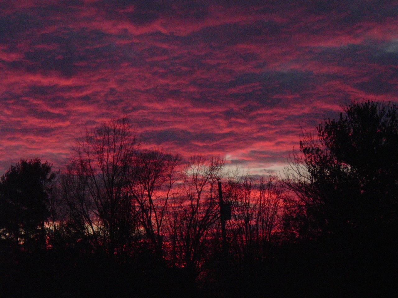
Great Sunset Photo
These were taken on Saturday evening!


A cold front is approaching Middle Tennessee and with that, a bigtime chance for showers and thunderstorms. Winds will be STRONG from the South and Southwest with gusts up to 30 mph. Behind this front, temperatures across the Cumberland Plateau for the workweek will be chilly. (Our forecast here!)
November Climate Summary is available by going here.
Middle Tennessee Fun Weather Fact of the Day:
On December 2, 1991...Nashville measures 3.07" of rainfall, for a 3-day total of 5.96". Crossville receives 3.57" for a remarkable 3-day total of 8.16".
Off topic a second, it appears the BCS Championship Game will be the Ohio State Buckeyes and the Louisiana State University Tigers. In all fairness, these are probably the right two teams, HOWEVER, if we had a playoff (like 1-AA) this all would be moot. I'd put OSU, LSU, Oklahoma, USC and Georgia in a five team playoff scenario over a three-week period with the #1 team getting a bye the first playoff week & wrap this all up by New Year's Day (like it ought to be). Let the other teams that didn't get in the playoffs play in Bowl Games. My opinion!
All Polls (courtesy of CBS Sportsline)
BCS 'Official Website'
Subscribe to:
Posts (Atom)
AMS
Member-American Meteorological Society